

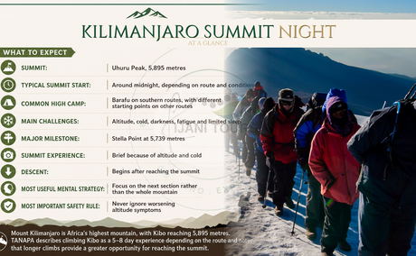
Kilimanjaro Summit Night: The Final Hours Before Uhuru Peak At midnight, the mountain disappears. Your headlamp becomes your horizon. Kilimanjaro summit night is the final and most demanding stage of the journey to Uhuru Peak at 5,895 metres. Starting around midnight, climbers face several hours of darkness, cold, fatigue, limited sleep and reduced oxygen availability. The challenge is physical, but it is also deeply mental. The key to managing summit night is...
The Complete Mount Kilimanjaro Guide: Africa’s Highest Free-Standing Mountain
Posted by Wolfgang on Sun March 16, 2025 in Tanzania’s UNESCO Treasures: Kilimanjaro and beyond.
Mount Kilimanjaro is more than Africa’s highest mountain. Rising to 5,895 metres above sea level, this ancient volcanic massif is a place where geology, biodiversity, climate, and human culture meet. From its snow-covered summit and dormant volcanic crater to its tropical forests and Chagga farming communities, Kilimanjaro contains several worlds within one mountain.
What makes Mount Kilimanjaro mysterious?
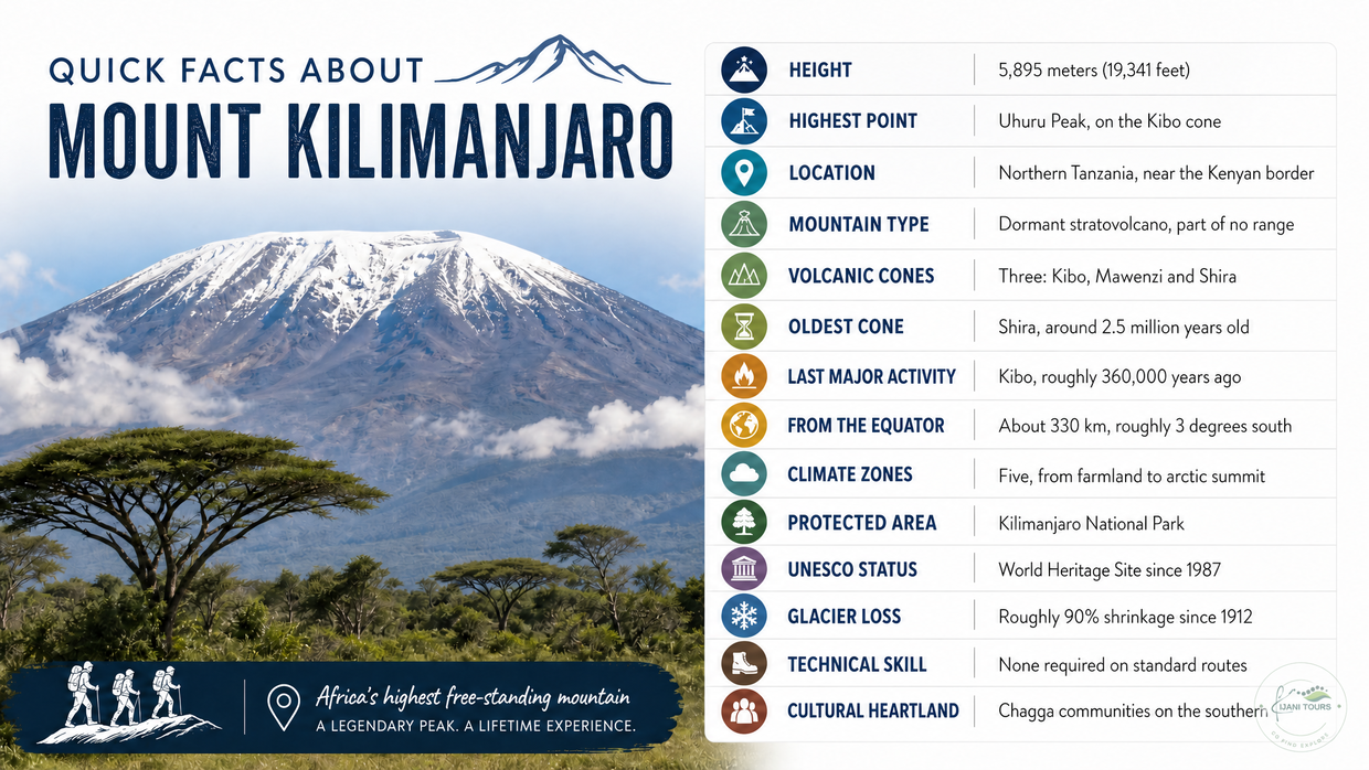
Kilimanjaro is mysterious because it holds combinations that should not coexist: glaciers on the equator, a dormant volcano still venting steam, five climate zones stacked on one slope, and a name no linguist can definitively translate. It rises alone from the Tanzanian plains rather than as part of a range, reaching 5,895 meters, which makes it the highest mountain in Africa and the tallest free-standing mountain on Earth.
Beyond the headline facts sits a more interesting story. Kilimanjaro is a living landscape where geology, ecology, culture, and conservation are physically connected. The volcanic eruptions that built it also made the soil that feeds the Chagga farms below. The forest that shelters its wildlife is the same forest that captures the water those farms depend on. Pull one thread and the rest moves.
Quick facts about Mount Kilimanjaro
Fact 1: What Does the Name “Kilimanjaro” Mean?
The honest answer is that nobody knows for certain. The origin of the name Kilimanjaro remains one of the mountain’s oldest unanswered questions, and it continues to attract debate among linguists, historians, and researchers. While many visitors know it as the “Mountain of Light” or “Shining Mountain,” this popular interpretation is only one of several theories and is not universally accepted.
The most common explanation connects the Swahili word “kilima,” meaning “hill” or “small mountain,” with a word believed to relate to whiteness or brightness, referring to Kilimanjaro’s snow-covered summit. This interpretation became widely accepted because the image of a white mountain rising above the African plains naturally inspired descriptions of a shining or bright peak.
However, the evidence behind this translation is not conclusive. The Chagga communities who have lived on Kilimanjaro’s slopes for centuries do not recognise “Kilimanjaro” as a word from their own languages. This has led some researchers to question whether the name is truly a simple combination of Swahili and Chagga words, as the popular explanation suggests.
Some linguists have proposed alternative Chagga-based interpretations. Research by linguist J. A. Hutchinson suggested that the name may be connected to Chagga words expressing the idea of something difficult to overcome or defeat. His interpretations have included possible meanings such as “that which defeats the bird” or “that which defeats the caravan,” reflecting the overwhelming scale and challenge of the mountain rather than its physical appearance.
Other historical accounts add further complexity. Early European visitors recorded different interpretations of the name, influenced by the languages and cultures they encountered around East Africa. Some connected it with ideas of greatness, caravans, or the mountain’s powerful presence. Even among local traditions, Kilimanjaro has carried meanings beyond a simple geographical name, representing a place of importance, identity, and connection between people and the landscape.
The uncertainty surrounding the name reflects the complex history of Kilimanjaro itself. The mountain has stood at the meeting point of different cultures, languages, and traditions for centuries—home to the Chagga people, known to traders and explorers, and later recognised around the world as one of Earth's most iconic mountains.
Perhaps the most accurate answer is that Kilimanjaro’s name remains a mystery. What is certain is the meaning the mountain holds today: a place where geology, culture, history, and human imagination come together on the slopes of Africa’s highest peak.
Fact 2: How Can Kilimanjaro Have Glaciers Near the Equator?
One of Mount Kilimanjaro’s most famous mysteries is the presence of ice and glaciers in tropical Africa. At first glance, a snow-covered mountain near the equator seems impossible. However, the explanation lies in altitude. Although Kilimanjaro is located only about three degrees south of the equator, its summit rises nearly 6,000 meters above sea level, where temperatures remain cold enough for ice to persist.
The mountain illustrates an important scientific principle: elevation can influence climate more strongly than latitude. Kilimanjaro’s glaciers are not merely beautiful features. They are historical records that provide scientists with information about past climate conditions and environmental change.
Today, these glaciers are retreating because of changing climatic conditions, making Kilimanjaro an important symbol in global climate research.
Fact 3: Is Mount Kilimanjaro an active volcano?
Mount Kilimanjaro is not an active volcano, but neither is it extinct. It is scientifically classified as a dormant stratovolcano—a mountain whose eruptions ceased long ago but whose volcanic system has not completely died. While there is no evidence of an imminent eruption, geothermal activity still exists beneath the summit. Inside Kibo Crater, sulphur-rich fumaroles continue to release volcanic gases, and residual heat remains deep below the surface, reminding visitors that Kilimanjaro is a sleeping volcano rather than a lifeless one. This distinction is important because many sources incorrectly describe the mountain as extinct.
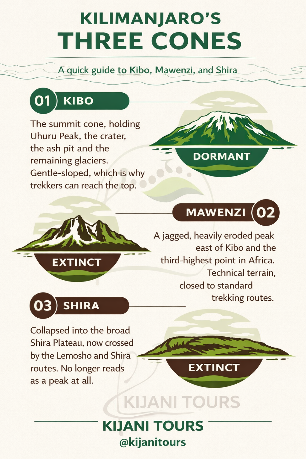
Kilimanjaro's remarkable landscape was shaped by millions of years of volcanic activity and is composed of three distinct volcanic cones, each representing a different chapter in the mountain's geological evolution.
Kibo, the youngest and largest cone, dominates the massif and is home to Uhuru Peak (5,895 metres / 19,341 feet), the highest point in Africa. Its broad summit crater, inner cone, and central ash pit are lasting evidence of its volcanic past. Kibo is also the only cone that retains geothermal activity today. Although its last major eruptive phase occurred approximately 360,000 years ago, sulphurous steam continues to escape through fumaroles within the crater, demonstrating that volcanic processes have not entirely ceased.
Mawenzi, rising dramatically to the east, is Kilimanjaro's oldest standing peak after extensive erosion. Its jagged spires, steep gullies, and rugged volcanic rock create one of Africa's most striking alpine landscapes. Unlike Kibo, Mawenzi has been inactive for much longer, with thousands of years of weathering sculpting its distinctive silhouette.
Shira is the oldest of Kilimanjaro's three volcanic cones. Over immense geological timescales, erosion caused much of the original cone to collapse, leaving behind the expansive Shira Plateau that trekkers cross on the Shira and Lemosho Routes. Today, the plateau offers one of the mountain's finest examples of how volcanic landscapes gradually evolve under the forces of wind, rain, and time.
Together, Kibo, Mawenzi, and Shira tell the complete geological story of Mount Kilimanjaro—a mountain built by successive volcanic eruptions over millions of years and later shaped by glaciation, erosion, and tectonic forces. Far from being simply Africa's highest peak, Kilimanjaro is one of the world's most fascinating dormant volcanoes, where visitors can walk across ancient lava fields, stand beside volcanic craters, and witness subtle signs that the mountain's volcanic heart still endures beneath the surface.
Fact 4: How was Mount Kilimanjaro formed?
Mount Kilimanjaro formed over millions of years through powerful volcanic activity associated with the East African Rift System, one of the world's largest active geological rift zones. As the African tectonic plate slowly split, magma rose through fractures in the Earth's crust, triggering successive eruptions that deposited layers of lava, ash, and volcanic rock. These eruptions gradually built the immense Kilimanjaro massif, forming Africa's highest mountain and the world's tallest free-standing mountain.
Rather than forming in a single event, Kilimanjaro developed through the growth of three volcanic cones, each representing a different stage in the mountain's geological evolution. Shira, formed about 2.5 million years ago, was the first volcano to emerge. Over time, its summit collapsed, leaving the expansive Shira Plateau, which hikers cross today on the Lemosho and Shira trekking routes. Mawenzi formed next, rising as a steep volcanic peak that has since been sculpted by erosion over hundreds of thousands of years into its distinctive jagged ridges. Finally, Kibo, the youngest and largest cone, experienced major cone-building eruptions around 460,000 years ago, eventually becoming Kilimanjaro's dominant summit and home to Uhuru Peak (5,895 meters / 19,341 feet).
Successive eruptions continued to build new layers of lava, volcanic ash, and rock, shaping the mountain into the iconic landscape seen today. Although volcanic activity ceased hundreds of thousands of years ago, Kibo remains a dormant volcano, with fumaroles in its summit crater still releasing sulfur-rich gases—evidence that geothermal activity persists beneath Africa's highest peak.
Why Is the Soil Around Mount Kilimanjaro So Fertile?
One of Kilimanjaro's most remarkable geological legacies lies not only in its towering summit but also in the fertile landscapes surrounding it. The same volcanic eruptions that built the mountain produced mineral-rich volcanic soils that, over thousands of years, weathered into exceptionally productive farmland. Together with reliable rainfall, streams fed by the mountain's forests, and seasonal meltwater, these nutrient-rich soils support one of East Africa's most successful agricultural regions.
Today, Kilimanjaro's southern and eastern slopes are home to thriving Chagga farming communities whose generations of knowledge have transformed the volcanic landscape into productive agroforestry systems. Here, Arabica coffee, bananas, maize, beans, avocados, and a wide variety of vegetables flourish under a natural canopy of indigenous trees. These traditional farming practices not only sustain local livelihoods but also conserve biodiversity, protect water catchments, and preserve the mountain's ecological balance.
Perhaps the most fascinating fact about Mount Kilimanjaro is that the volcano that once reshaped the landscape with fire and lava eventually became the foundation for one of Tanzania's richest agricultural regions. What began as a series of volcanic eruptions millions of years ago now supports vibrant communities, world-renowned coffee cultivation, and sustainable farming traditions that continue to define life on the mountain today.
Fact 5: The Frozen Leopard of Kilimanjaro: One of Africa's Greatest Mountain Mysteries
Among the many stories hidden within Mount Kilimanjaro's history, few are as fascinating as the discovery of a frozen leopard near the summit of Kibo Crater. In 1926, Lutheran pastor Richard Reusch found the preserved remains of a leopard close to the crater rim at approximately 5,700 metres above sea level—an extraordinary altitude for a large African predator. The discovery immediately raised a remarkable question: why would a leopard climb so close to the icy summit of Africa's highest mountain?
The exact reason remains unknown. Leopards are highly adaptable animals capable of travelling across diverse landscapes, and the animal may have followed prey, explored unfamiliar territory, or become trapped by the extreme conditions of the upper mountain. At this altitude, however, there is little food, shelter, or suitable habitat for a predator, making the discovery one of Kilimanjaro's most enduring natural mysteries.
The story became internationally famous through Ernest Hemingway's 1936 short story "The Snows of Kilimanjaro," which opens with the image of a frozen leopard near the summit. The real discovery transformed from a historical observation into a symbol of the mountain's isolation, mystery, and the powerful connection between life and the extreme environments found on Kilimanjaro.
Today, the frozen leopard itself is gone. Still, its story remains one of the most intriguing facts about Mount Kilimanjaro—a reminder that this mountain is not only a geological wonder but also a place where wildlife, exploration, history, and human imagination meet.
Fact 6: What Are the Five Climate Zones of Mount Kilimanjaro?
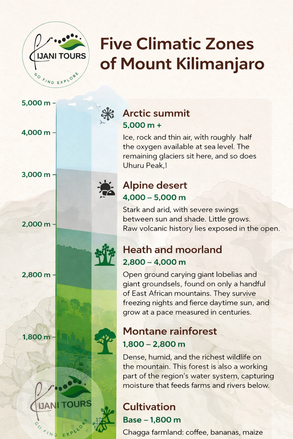
One of the most remarkable facts about Mount Kilimanjaro is that a single trek can take you through five different climate and ecological zones—from tropical farmland at the mountain's base to an Arctic-like environment at the summit. As altitude increases, temperature, rainfall, vegetation, and wildlife change dramatically, creating a natural journey through several distinct ecosystems within just a few days.
Kilimanjaro's five ecological zones are shaped by elevation, climate, and the mountain's unique position near the Equator. Trekkers experience these zones in sequence while ascending toward Uhuru Peak (5,895 metres / 19,341 feet), Africa's highest point.
1. Cultivated Farmland Zone (approximately 800–1,800 metres)
The journey begins on the fertile lower slopes of Kilimanjaro, where volcanic soils support some of Tanzania's most productive agricultural landscapes. This is the home of the Chagga communities, who have cultivated the mountain for generations using traditional agroforestry systems.
Bananas, Arabica coffee, maize, beans, and vegetables grow beneath a canopy of trees, creating a living landscape where agriculture, culture, and conservation are closely connected. The same volcanic forces that created Kilimanjaro also created the fertile soils that sustain communities today.
2. Montane Rainforest Zone (approximately 1,800–2,800 metres)
Above the farms lies the lush montane rainforest, one of Kilimanjaro's most important ecological zones. Heavy rainfall and cooler temperatures create dense forests filled with ancient trees, mosses, ferns, and climbing plants.
This forest acts as a natural water tower, capturing rainfall and releasing water gradually through streams and springs that support ecosystems and communities below. Wildlife found here includes blue monkeys, colobus monkeys, birds, and many smaller forest species.
3. Heath and Moorland Zone (approximately 2,800–4,000 metres)
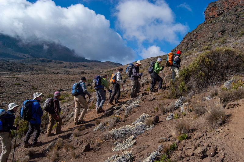
As the forest begins to disappear, the landscape opens into the unique heath and moorland zone. Here, vegetation becomes specially adapted to colder temperatures, intense sunlight, and dramatic changes between day and night.
This zone is famous for Kilimanjaro's unusual giant plants, including giant groundsels and giant lobelias, species that have evolved remarkable adaptations to survive the mountain's harsh conditions. The landscape changes from dense forest into open valleys, volcanic slopes, and high-altitude vegetation.
4. Alpine Desert Zone (approximately 4,000–5,000 metres)
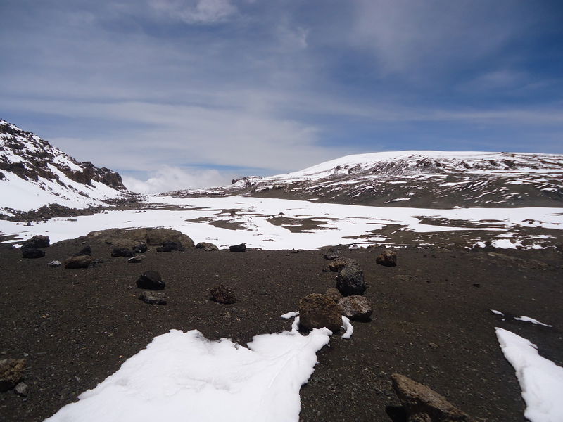
Above the moorland, Kilimanjaro becomes a world of extremes. The alpine desert receives very little rainfall, and temperatures can change rapidly between intense daytime sun and freezing nighttime conditions.
Vegetation becomes sparse, with only specially adapted plants surviving among volcanic rocks and exposed terrain. This zone represents the transition between the living ecosystems below and the extreme summit environment above.
5. Arctic Summit Zone (above approximately 5,000 metres)
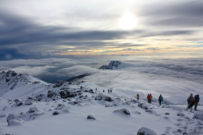
The final stage of the climb enters Kilimanjaro's summit zone, where conditions resemble a polar environment despite being located near the Equator. Temperatures drop below freezing, oxygen levels are significantly reduced, and the landscape is dominated by volcanic rock, ice, and glaciers.
At this altitude, there is almost no vegetation or wildlife. The summit zone reveals the powerful effects of altitude, where the environment is shaped more by freezing temperatures and thin air than by the tropical location below.
A Mountain That Contains Several Worlds
Few places on Earth allow people to walk through such dramatic ecological transitions in a single journey. On the slopes of Mount Kilimanjaro, a trekker can begin among coffee farms and tropical forests, pass through landscapes of giant mountain plants, cross a high-altitude desert, and finally stand in an icy summit environment above the clouds.
Kilimanjaro is not only Africa's highest mountain—it is a living ecological staircase that reveals how life changes with altitude.
Fact 7: Are Kilimanjaro’s glaciers really disappearing?
Yes, and fast. Kilimanjaro’s ice has shrunk by roughly 90 percent since it was first mapped in 1912, and the rate of loss has accelerated. UNESCO and multiple researchers project that the glaciers could disappear around the middle of this century. The primary driver is a warming climate, compounded by changes in precipitation and cloud cover over the summit.
Douglas Hardy, a glacier and climate specialist who has studied the mountain’s ice since 2000, has documented dramatic recent retreat, including a striking reduction in the Furtwängler Glacier, the small remnant near the summit long associated with the mountain, over just a few years in the early 2020s.
Projections vary in their timing. The direction does not. Some researchers now consider the eventual loss of Kilimanjaro’s ice effectively inevitable under current conditions. The consequences extend beyond the loss of a spectacle. The glaciers and the montane forest below them are part of the water system that feeds the rivers, farms, and communities of the Kilimanjaro Region. When people here talk about saving the mountain, they mean livelihoods as much as scenery.
Fact 8: The Hidden Biodiversity of Mount Kilimanjaro
Mount Kilimanjaro is often recognised as a world-famous trekking destination, but its importance extends far beyond the summit. Beneath the glaciers and volcanic landscapes is a complex living ecosystem where forests, plants, birds, and wildlife have adapted to survive across one of the most dramatic changes in altitude found anywhere on Earth.
A journey up Kilimanjaro is also a journey through different habitats. The mountain’s slopes contain a remarkable sequence of ecological zones, each supporting its own forms of life. From fertile farmland on the lower slopes to dense montane rainforest, open moorland, and the harsh alpine environment near the summit, every stage of the climb reveals a different expression of nature.
The lower slopes of Kilimanjaro are shaped by the relationship between people and the environment. The rich volcanic soils created by ancient eruptions support agricultural landscapes where Chagga communities have cultivated coffee, bananas, vegetables, and other crops for generations. Beyond the farms, forest patches and natural corridors provide important habitats for birds, mammals, and countless smaller species. As trekkers enter the montane rainforest zone, the character of the mountain changes completely. Towering trees, moss-covered branches, ferns, and dense vegetation create a cool, misty world that plays a vital role in protecting Kilimanjaro’s water sources. This forest captures rainfall, stores moisture, and releases water gradually through streams that support ecosystems and communities below. Within this green landscape live species such as blue monkeys, colobus monkeys, forest birds, and other mammals adapted to life among the trees.
Higher on the mountain, the vegetation becomes increasingly specialised. The heath and moorland zone is home to some of Kilimanjaro’s most remarkable plants, including giant groundsels and giant lobelias. These unusual species demonstrate the power of evolution, developing unique adaptations that allow them to survive intense sunlight, freezing nights, and dramatic temperature changes. Their presence makes Kilimanjaro one of the most fascinating places to observe high-altitude plant life.
Above the moorland, the alpine desert creates a landscape of volcanic rock, thin air, and extreme conditions. Life becomes scarce, but not absent. Specially adapted organisms survive in this challenging environment, showing the resilience of nature even where conditions appear almost impossible.
The wider Kilimanjaro ecosystem also supports a surprising diversity of wildlife beyond the trekking routes. In the forests and surrounding protected areas, species such as elephants, buffalo, bushbuck, duikers, and numerous bird species move through habitats connected to the mountain. These animals depend on the continued protection of forests, water sources, and natural corridors around Kilimanjaro.
The biodiversity of Mount Kilimanjaro tells a deeper story about the mountain. It is not only a volcanic peak to climb, but a living landscape where geology, climate, plants, wildlife, and human communities are connected. Protecting Kilimanjaro means preserving an entire ecosystem—one where ancient forests protect water, unique plants reveal the power of adaptation, and wildlife continues to thrive alongside the people who call the mountain home.
Fact 9: How Did the Chagga Build a Farming Society on the Slopes of a Volcano?
The fertile landscapes surrounding Mount Kilimanjaro were not created by nature alone. For centuries, the Chagga people developed sophisticated farming systems that transformed the mountain’s steep volcanic slopes into productive agricultural landscapes. Their success was not a matter of chance—it was the result of generations of ecological knowledge, careful water management, and a deep understanding of the mountain environment.
One of the greatest examples of this knowledge is the traditional mfongo irrigation system. These hand-built furrows channel water from Kilimanjaro’s forests, streams, and mountain springs down to farms below, allowing communities to distribute water across steep terrain. Built, maintained, and managed collectively, the furrows were governed by local agreements that ensured fair access, regular maintenance, and protection of this valuable resource.
The Chagga also developed a unique form of agroforestry known as the kihamba farming system. Instead of clearing large areas for single crops, farmers created layered home gardens where different plants grow together in harmony. Tall shade trees protect coffee plants, banana plants provide food and organic matter, while vegetables and other crops grow beneath them. This multi-layered approach improves soil health, reduces erosion, and allows families to produce food from relatively small areas of land.
These traditional practices reveal an important lesson: living with a volcano requires understanding its rhythms. The same volcanic soils that created the mountain’s dramatic landscape also provided the foundation for agriculture. By combining fertile soils, careful water management, and generations of farming knowledge, the Chagga created one of East Africa’s most productive mountain farming systems.
But the relationship between the Chagga and Kilimanjaro has always been more than agricultural. The mountain has shaped identity, traditions, stories, and beliefs for generations. The snow-covered summit of Kibo held deep cultural significance, and many Chagga communities developed oral traditions connecting the mountain with ancestors, spiritual beliefs, rainfall, and the forces that sustain life.
For the Chagga, Kilimanjaro was never simply a backdrop or a challenge to climb. It was a source of water, food, identity, and belonging. The forests provided resources, the rains determined harvests, and the mountain remained a central presence in everyday life.
Today, visiting a Chagga coffee farm, walking through traditional home gardens, or learning about the mfongo irrigation system offers a different way to experience Kilimanjaro. It reveals the mountain not only as a geological wonder, but as a living landscape shaped by the knowledge and stewardship of the people who have called its slopes home for centuries.
Fact 10: The Explorers Who Revealed Kilimanjaro’s Secrets
For centuries, Mount Kilimanjaro stood at the edge of the known world for many outsiders, a vast volcanic mountain rising from the plains of East Africa, with a snow-covered summit that seemed impossible so close to the Equator. Reports of ice and snow on a tropical mountain challenged many European geographical beliefs of the nineteenth century and created one of Africa’s greatest exploration questions.
The first widely recorded account came in 1848, when German missionary Johannes Rebmann reported seeing a snow-covered mountain while working in the Kilimanjaro region. His observations were met with disbelief by many European geographers, who considered permanent snow near the Equator unlikely. For years, his description was questioned until later expeditions confirmed that Africa’s highest mountain truly carried glaciers and ice at its summit.
As interest in Kilimanjaro grew, explorers attempted to understand and reach the mountain’s upper slopes. The challenge was not only the altitude but also the complexity of the volcanic landscape, unpredictable weather, and the need for detailed knowledge of the mountain environment.
On 6 October 1889, German geographer Hans Meyer and Austrian mountaineer Ludwig Purtscheller reached the summit of Kibo, the highest volcanic cone of Kilimanjaro. Their achievement marked the first confirmed ascent of Africa’s highest mountain. However, their success was made possible through the guidance and experience of Yohani Kinyala Lauwo, a young Chagga guide from the Kilimanjaro region.
Lauwo’s contribution was far more than simply accompanying the expedition. He understood the mountain’s terrain, conditions, and pathways in ways that outside explorers could not. His knowledge of Kilimanjaro was essential in navigating the route to the summit, and he later continued guiding climbers on the mountain for many years.
The history of Kilimanjaro’s first ascent is therefore not only a story of European exploration, but also a story of local expertise. The mountain was not an unknown wilderness waiting to be discovered—it was already part of the landscape, culture, and knowledge system of the communities living around it.
Today, Yohani Kinyala Lauwo is recognised in Tanzania as a central figure in Kilimanjaro’s climbing history. His story reflects an important truth about mountain exploration: successful journeys to the summit are built not only on ambition and equipment, but also on the knowledge of people who have lived alongside the mountain for generations.
The story of Kilimanjaro’s exploration is ultimately a shared history—one that combines scientific curiosity, human determination, and the invaluable guidance of local communities who have always understood the mountain.
Fact 11: Is Mount Kilimanjaro the Tallest Mountain in the World?
Mount Kilimanjaro is not the tallest mountain in the world, but it holds a unique distinction that makes it one of the planet’s most remarkable peaks. The title of the world’s highest mountain above sea level belongs to Mount Everest, which rises to 8,849 metres (29,032 feet) above sea level. Kilimanjaro reaches 5,895 metres (19,341 feet) and is recognised as the highest mountain in Africa and the tallest free-standing mountain in the world.
The phrase “free-standing mountain” is where much of the confusion comes from. Unlike Everest, which forms part of the vast Himalayan mountain range, Kilimanjaro stands independently on the East African plains. It is a single volcanic massif rising dramatically from the surrounding landscape, allowing visitors to see the mountain’s full height and shape from a great distance.
This unique position gives Kilimanjaro one of the greatest vertical rises of any mountain on Earth. From the cultivated farmlands at its base to the icy summit of Kibo, the mountain climbs through forests, moorlands, alpine deserts, and glaciers in a continuous natural journey.
Kilimanjaro’s importance is therefore not measured only by altitude. It represents a different kind of mountain experience—one where a solitary volcanic peak rises from the African landscape, creating a complete ecosystem and cultural landmark within a single mountain.
For many climbers, standing on Uhuru Peak is not about reaching the highest point on Earth. It is about experiencing the extraordinary transition from tropical Africa to an Arctic-like summit environment on one of the world’s most iconic free-standing mountains.
Fact 12: Can a beginner climb Mount Kilimanjaro?
Yes, most people who summit are not mountaineers. The standard routes require no ropes, harnesses, crampons, or technical skill. Success depends far more on acclimatization than on athleticism, which is why longer routes yield higher summit rates than shorter ones, and why fit young climbers fail while slower, older ones succeed.
This is the most useful advice we can give a first-time trekker: the mountain is not testing your fitness; it is testing how your body handles thin air over time. The only reliable way to influence that is to give yourself more days.
What actually determines the outcome:
• Route length. More days on the mountain is the single biggest factor you can control.
• Pace. Pole pole, slowly slowly, is not a saying. It is a method.
• Hydration and honesty. Drink more than you feel necessary and tell your guides exactly how you feel.
• Guide quality. Experienced guides spot altitude-related problems before you do.
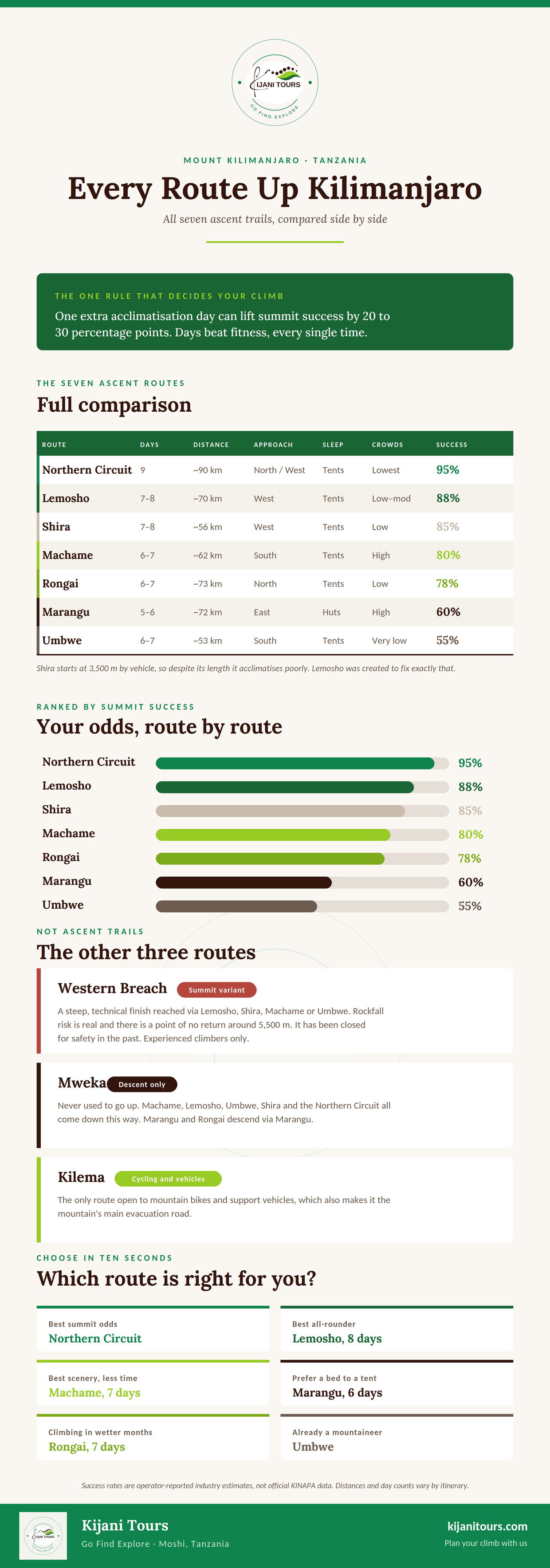
See the infographics below, and our altitude advice for the details.
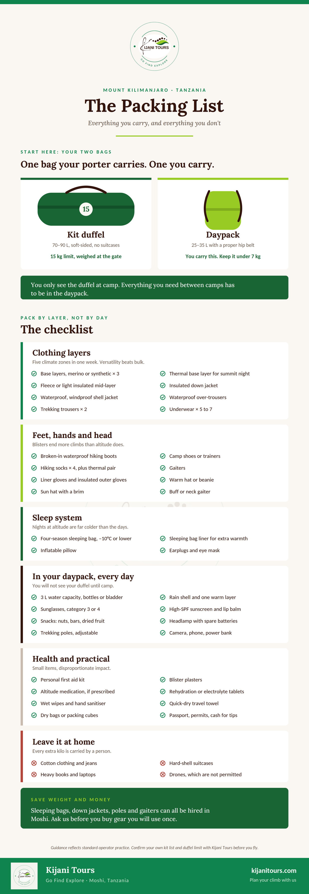
Kilimanjaro preparation guide, packing list
See the infographics about the route comparison below
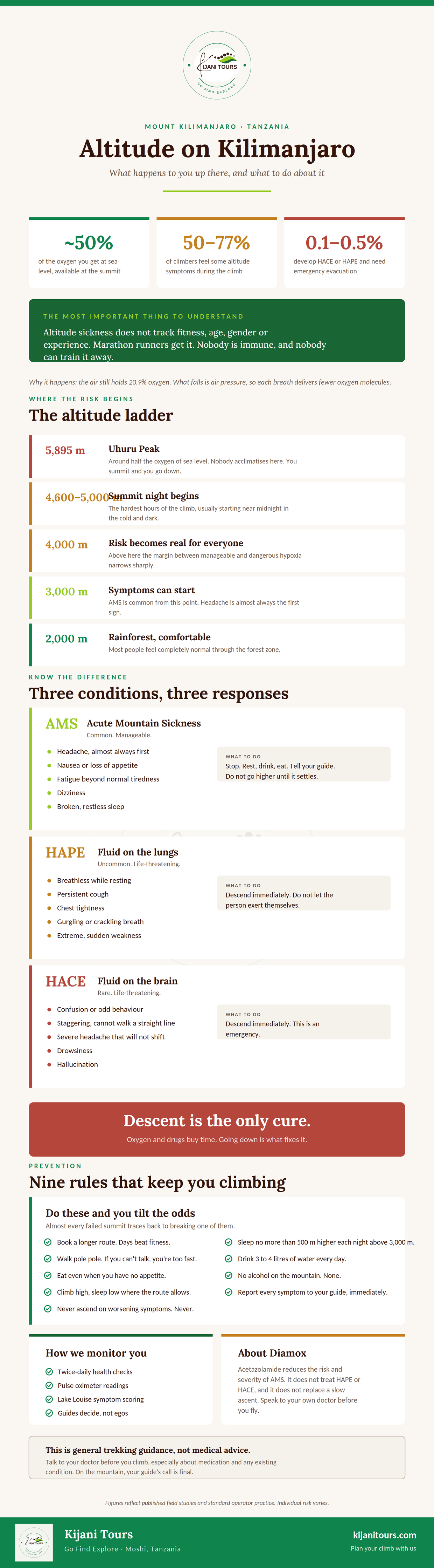
See the altitude advice for the details
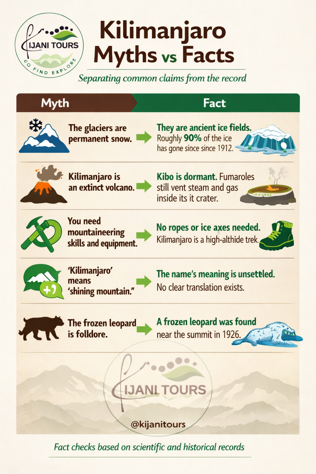
Kilimanjaro myths versus facts
Five claims that circulate widely, checked against the record.
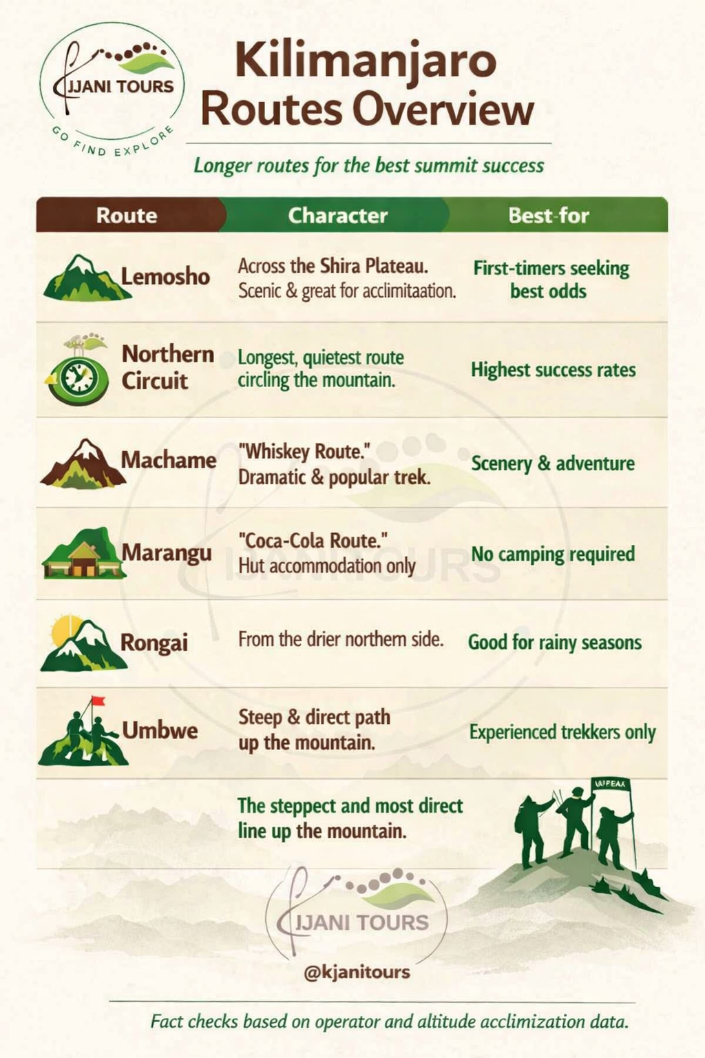
Which Kilimanjaro Route Should You Choose?
Choosing the right Mount Kilimanjaro route is one of the most important decisions when planning your climb. Each route offers a different combination of scenery, difficulty, duration, and acclimatisation opportunities, and the best choice depends on your experience, fitness level, available time, and how your body responds to altitude. In general, longer routes with gradual altitude gain provide the best conditions for acclimatisation. Spending more days on the mountain allows your body to adjust naturally to the decreasing oxygen levels, which can significantly improve your chances of reaching Uhuru Peak (5,895 metres) safely and successfully.
The Lemosho Route and Northern Circuit Route are among the strongest options for climbers prioritising acclimatisation. Both approaches allow a longer journey through Kilimanjaro’s changing landscapes, from rainforest and moorland to the high alpine environment, while giving your body more time to adapt before the summit attempt. The Machame Route, often called the “Whiskey Route,” is one of the most popular choices because of its dramatic scenery and varied landscapes. Its approach combines beautiful terrain with a challenging trekking profile and is well suited to climbers looking for a classic Kilimanjaro experience.
The Marangu Route is unique because it is the only Kilimanjaro route that offers dormitory-style hut accommodation instead of camping. Known as the “Coca-Cola Route,” it follows a more direct path to the summit and is often chosen by trekkers who prefer fixed shelters. The Rongai Route approaches Kilimanjaro from the northern side near the Kenya border. It is generally quieter than the southern routes and passes through a drier landscape, offering a different perspective of the mountain.
The Umbwe Route is the shortest and steepest approach to Kilimanjaro. Because of its rapid altitude gain and demanding terrain, it is recommended for experienced trekkers who are comfortable with challenging climbs and have previous high-altitude experience. Ultimately, the best Kilimanjaro route is not simply the fastest way to the summit. It is the route that matches your goals, allows proper acclimatisation, and gives you time to experience the mountain’s changing ecosystems, landscapes, and quiet moments along the way.
Why We Recommend a Longer Kilimanjaro Route
When choosing a Kilimanjaro route, we recommend allowing enough time for your body to adapt to the altitude. The difference between a shorter and longer itinerary is often only a few additional days, but those extra days can make a significant difference in your overall experience on the mountain. Reaching the summit of Kilimanjaro is not only about physical fitness. Altitude affects every climber differently, and the body needs time to adjust to lower oxygen levels. Acclimatisation is built through gradual elevation gain, rest, and steady progress on the mountain; it cannot simply be replaced by training harder before your trip.
A longer route gives you more time to walk through Kilimanjaro’s changing landscapes, recover between stages, and approach summit day with greater confidence. The additional investment in time is small compared with the value of having a safer, more enjoyable, and more rewarding journey to the roof of Africa.
Mount Kilimanjaro Frequently Asked Questions
1. Why does Mount Kilimanjaro have glaciers near the equator?
Kilimanjaro has glaciers because of altitude, not latitude. Its summit reaches 5,895 metres, where temperatures stay below freezing year-round regardless of the mountain’s position roughly 330 kilometres from the equator. The ice fields are ancient, dating back thousands of years, rather than seasonal snowfall.
2. What does the name "Kilimanjaro" mean?
Nobody knows for certain. The popular reading combines Swahili kilima (hill) with Chagga njaro (whiteness) to give "shining mountain," but linguists dispute it, and the Chagga do not treat "Kilimanjaro" as a word from their own language. The linguist J. A. Hutchinson proposed Chagga roots meaning "that which defeats the caravan" or "that which defeats the bird." No explanation is accepted as definitive.
3. Is Mount Kilimanjaro an active volcano?
Kilimanjaro is dormant, not extinct. Its highest cone, Kibo, last had significant volcanic activity roughly 360,000 years ago, but fumaroles inside its crater still vent sulphurous steam and gas, showing residual geothermal heat below the summit. There is no sign of an imminent eruption, and the mountain is monitored.
4. How was Mount Kilimanjaro formed?
Kilimanjaro was built by volcanic activity along the East African Rift, where the continent is slowly splitting apart. Three cones formed in sequence: Shira around 2.5 million years ago, then Mawenzi, then Kibo with a major cone-building eruption around 460,000 years ago. Layers of lava, ash, and volcanic rock accumulated to create the massif.
5. How tall is Mount Kilimanjaro?
Mount Kilimanjaro stands 5,895 metres (19,341 feet) at Uhuru Peak, its highest point, making it the tallest mountain in Africa and the tallest free-standing mountain in the world.
6. Is Kilimanjaro the tallest mountain in the world?
No. Mount Everest is the highest mountain above sea level at 8,849 metres. Kilimanjaro, at 5,895 metres, is the highest mountain in Africa and the tallest free-standing mountain in the world, meaning it rises alone from the surrounding plains rather than forming part of a mountain range.
7. Are Kilimanjaro’s glaciers disappearing?
Yes. Kilimanjaro’s ice has shrunk by roughly 90 percent since it was first mapped in 1912, and the rate of loss has accelerated. UNESCO and multiple researchers project the glaciers could disappear around the middle of this century. The primary driver is a warming climate, compounded by changes in precipitation and cloud cover.
8. What are the five climate zones of Kilimanjaro?
Kilimanjaro has five climate zones: cultivation (base to 1,800 m), montane rainforest (1,800 to 2,800 m), heath and moorland (2,800 to 4,000 m), alpine desert (4,000 to 5,000 m), and arctic summit (above 5,000 m). Climbers pass through all five on the way to Uhuru Peak.
9. What animals live on Mount Kilimanjaro?
The montane rainforest zone holds the richest wildlife, including blue monkeys, black-and-white colobus monkeys, bushbuck, bushbabies and many bird species. Elephants, buffalo and leopards inhabit the forest and lower slopes but are rarely seen on busy trekking routes. Wildlife thins out sharply above the moorland zone.
10. Why was a frozen leopard found on Kilimanjaro?
In 1926, a frozen leopard carcass was found near Kilimanjaro’s crater rim above 5,300 metres, far higher than leopards normally venture. Why it climbed into the mountain’s arctic zone has never been explained. Ernest Hemingway referenced the discovery in his short story The Snows of Kilimanjaro.
11. Who was the first person to climb Mount Kilimanjaro?
German geographer Hans Meyer and Austrian mountaineer Ludwig Purtscheller reached Kibo’s summit on 6 October 1889, guided by Yohani Kinyala Lauwo, a local Chagga man. Lauwo went on to guide on the mountain for decades and is recognised in Tanzania as central to the achievement.
12. Do you need climbing experience to summit Kilimanjaro?
No. The standard routes require no ropes, harnesses, crampons or technical mountaineering skills. Kilimanjaro is a high-altitude trek rather than a climb. The main difficulty is altitude, which is best managed by choosing a longer route, ascending slowly and climbing with experienced guides.
13. Can a beginner climb Mount Kilimanjaro?
Yes. Many first-time trekkers summit Kilimanjaro successfully. Success depends far more on acclimatisation than athleticism, which is why longer routes such as Lemosho and the Northern Circuit produce better summit rates than short ones. Reasonable fitness, sensible pacing and experienced guides matter more than prior mountain experience.
14. Which Kilimanjaro route is best for beginners?
Longer routes with strong acclimatisation profiles suit first-time trekkers best. Lemosho and the Northern Circuit give the most gradual ascent and the highest summit success rates. Machame is a popular scenic option. Umbwe is the steepest and is not recommended for beginners.
15. How many people climb Kilimanjaro each year?
Tens of thousands of people attempt the summit annually, making Kilimanjaro one of the most climbed high mountains in the world and a cornerstone of Tanzania’s tourism economy, supporting thousands of guides, porters and cooks.
16. Responsible Tourism
Every responsible trek on Kilimanjaro contributes to protecting the mountain through conservation fees, employment opportunities, and support for local communities. Tourism does not stop global climate change, but it can help protect the ecosystems that remain.
A well-managed climb supports:
conservation of Kilimanjaro National Park
employment for local mountain crews
protection of forest ecosystems
community-based tourism initiatives
greater awareness of climate change impacts
At Kijani Tours, we believe climbing Kilimanjaro is not only about reaching the summit. It is about understanding the mountain, respecting its ecosystems, and ensuring that future generations can continue to experience this remarkable landscape.
closing paragraph
Mount Kilimanjaro has always been a mountain of change. Ancient volcanoes created it, forests sustain it, communities have shaped life around it, and glaciers have recorded thousands of years of climate history. The disappearing ice is a reminder that mountains are not frozen in time. They are living landscapes, constantly responding to the world around them. To climb Kilimanjaro today is not only to witness one of Africa’s greatest natural wonders. It is to become part of its continuing story.
Discover the Stories Behind the Summit
Mount Kilimanjaro is more than a mountain to climb. It is a living landscape shaped by ancient volcanic forces, changing ecosystems, unique wildlife, and generations of Chagga knowledge. To stand on Uhuru Peak is to experience only one part of the mountain’s story. The journey begins much earlier, walking through fertile foothills, entering ancient rainforest, crossing high-altitude landscapes, and learning about the people and environments that have shaped Kilimanjaro for centuries.
At Kijani Tours, we create Kilimanjaro experiences that connect you with the mountain beyond the summit. Our locally guided treks combine careful preparation, responsible travel practices, and deep knowledge of Kilimanjaro’s natural and cultural heritage. Choose your route, prepare for the journey, and discover Africa’s highest mountain through the stories, landscapes, and communities that make it truly unique.
Share This Post
Latest News
Tanzania Travel Guide | Safaris, Kilimanjaro, Beaches, Culture and Responsible Travel
Kilimanjaro Summit Night: How to Prepare Mentally and What to Expect
Sun August 30, 2026
Read This Article
Is Tanzania Safe for Kids on Safari?: A Parent's Guide to Family Safari in Tanzania, 2026–2029
Sat August 29, 2026
Read This Article
Planning a Tanzania safari with children? This practical family safari guide helps parents understand when to go, which parks and experiences suit different ages, how to prepare for health and safety, and what to expect from accommodations, game drives, and wildlife encounters. It also explains how Kijani Tours can tailor a private safari to your family's needs, from the Serengeti and Ngorongoro to cultural experiences and Tanzania's coast, from Pangani to Mafia...
Climbing Kilimanjaro as a Woman: What No One Tells You Before You Go
Thu August 27, 2026
Read This Article
Climbing Kilimanjaro as a woman is absolutely possible, but there are practical things to prepare for before you arrive. This guide covers the realities many women want to know about, including hygiene at mountain camps, managing your period, physical preparation, altitude sickness, and what to expect on summit night. You will also learn which questions to ask Kijani Tours' team regarding privacy, female guides, hygiene and waste management, health monitoring, and emergency...
Share This Post